Russia invaded Ukraine in 2014 with its army.
Google Earth reveals that this happened on numerous locations at the Ukrainian border.
Google Earth reveals that this happened on numerous locations at the Ukrainian border.
There are locations where hundreds of vehicles passed and locations where just a team with a mortar sneaked in, shelled a border post and sneaked back into Russia.
Here is the top ten of explicit examples.
We'll start with the Russian Donetsk area, where the 'official' Izvaryne border crossing is. It was the last area for Ukraine to close from Russian intrusions, but they never succeeded to do so.
We'll start with the Russian Donetsk area, where the 'official' Izvaryne border crossing is. It was the last area for Ukraine to close from Russian intrusions, but they never succeeded to do so.
Legend:
red arrow = major invasion
pink arrow = regular border crossing
light pink arrow = small regular border crossing
white arrow = small incursion
orange arrow = bigger incursion
blue area = Ukrainian camp/position
red/orange/pink/green area = Russian camp/position
yellow area = GRAD launches visible

Border crossing #1


By beginning of August 2014 we can see an attempt has been made to block these tracks again by digging another trench, but that one has been crossed too:

Also the area north of it now shows very intensive use. It looks like a dam breach :-).


And Google Earth:

Location of crossings #3 and #4:


A tank can be seen that had crossed the border and is waiting and/or guarding it.


Not far from there on November 21st a battle group can be seen positioned 2 kms from this crossing and facing towards it:

Likely they are about to cross the border there.
This geotagged photo from a VK-album shows the tent that can also be seen in the satellite image next to the trees:

More to the East a very large, newly discovered military camp can be seen:

A group of tanks can be seen driving out of the camp:


Border crossing #9
This is not a big one and it is very close to the Ilovaisk crossing, but it is an important one, because it shows Russian tanks and support vehicles WHILE they are crossing the border:

Border crossing #10
This 'road' leading to the Mariupol area, was 'opened' again by Russia:


Smaller examples


Here we can see 'something' happened in a field (orange area). Very small tracks (the thin white lines) lead to and from that position. They go downwards to the border (arrow).

The tracks are too small for a vehicle. It must be from people walking. So this must have been a mortar position that was used to shell the Ukrainian borderpost at Chervonopartyzansk (near Gukovo on Russian side).
After shelling they could quickly retreat to safety into Russia again.
This 2013 image already shows the border is porous. Several tracks lead in/out of Ukraine. This is either used by locals and/or for smuggling.

In May 2015 the tracks are different and more profound, meaning they are still being used and used more intense:
By beginning of August 2014 we can see an attempt has been made to block these tracks again by digging another trench, but that one has been crossed too:

Also the area north of it now shows very intensive use. It looks like a dam breach :-).
On August 31st we see that the trees had been used as a parking/camping ground (green square). This is a typical practice for military vehicles.


Any one of the border crossings in this area must have been used to transport the MH17 BUK across the border.
Border crossing #2

Any one of the border crossings in this area must have been used to transport the MH17 BUK across the border.
Border crossing #2
Not far from the first one another 'road' appeared:


This is not just a track anymore. It is so intensively used, it is a road by now. Dozens to hundreds of vehicles have passed here.
Border crossing #3


More to the East another camp can be seen:


This is not just a track anymore. It is so intensively used, it is a road by now. Dozens to hundreds of vehicles have passed here.
Border crossing #3
This location shows a military camp at different stages including vehicles, right at the border with tracks leading across it:


More to the East another camp can be seen:

On Yandex (unknown date) it looks like this:

And Google Earth:

Location of crossings #3 and #4:
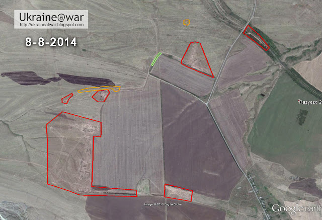
Border crossing #4
At this location a complete borderpost originated!


A tank can be seen that had crossed the border and is waiting and/or guarding it.


Not far from there on November 21st a battle group can be seen positioned 2 kms from this crossing and facing towards it:

Likely they are about to cross the border there.
This geotagged photo from a VK-album shows the tent that can also be seen in the satellite image next to the trees:

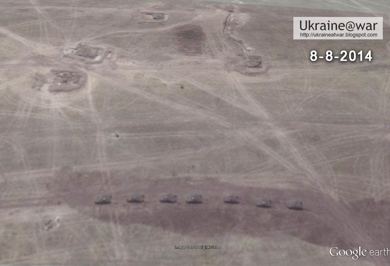
More to the East a very large, newly discovered military camp can be seen:


A group of tanks can be seen driving out of the camp:


An ammunition depot:

This camp can only be seen on the 8-8 image. It was very short-lived. It means they all drove into Ukraine, probably to fight at Lugansk Airport.


Border Crossing #5 - Dibrivka
This is the first major invasion area, covered in this blog. The goal was to block off the Ukrainian border troops. After this invasion, the other two big invasions (towards Lugansk Airport and Ilovaisk) could happen.

This camp can only be seen on the 8-8 image. It was very short-lived. It means they all drove into Ukraine, probably to fight at Lugansk Airport.
Not very far from there, two Pantsir Anti Air Defense Systems can be seen:


Border Crossing #5 - Dibrivka
This is the first major invasion area, covered in this blog. The goal was to block off the Ukrainian border troops. After this invasion, the other two big invasions (towards Lugansk Airport and Ilovaisk) could happen.
Border Crossing #6 - Marinovka
As can be seen on the map above, on the Russian side it has been really busy here. The Russians had been cutting of the Ukrainian army along the border at this location. Heavy fighting had been going on back and forth. The area shows numerous battle groups and incursions. But since this is an official border crossing with a road, most traffic can't be seen.
As can be seen on the map above, on the Russian side it has been really busy here. The Russians had been cutting of the Ukrainian army along the border at this location. Heavy fighting had been going on back and forth. The area shows numerous battle groups and incursions. But since this is an official border crossing with a road, most traffic can't be seen.
Nevertheless this image is especially interesting:

A Russian battle group of mainly BTRs just having passed the border, can be seen travelling into Ukraine:

On the day before, they were still at the Russian side of the border:

Border Crossing #7
A little bit South of Marinovka this can be seen:


No further explanation needed...
Border crossing #8 - Ilovaisk
After the Dibrivka and Marinovka invasion areas, this is a very big one, that lead to the Ilovaisk disaster. See this blog.
A Russian battle group of mainly BTRs just having passed the border, can be seen travelling into Ukraine:
On the day before, they were still at the Russian side of the border:
Border Crossing #7
A little bit South of Marinovka this can be seen:


No further explanation needed...
Border crossing #8 - Ilovaisk
After the Dibrivka and Marinovka invasion areas, this is a very big one, that lead to the Ilovaisk disaster. See this blog.
This is not a big one and it is very close to the Ilovaisk crossing, but it is an important one, because it shows Russian tanks and support vehicles WHILE they are crossing the border:

Border crossing #10
This 'road' leading to the Mariupol area, was 'opened' again by Russia:


Smaller examples
Just some examples of the smaller incursions which are countless:


Here we can see 'something' happened in a field (orange area). Very small tracks (the thin white lines) lead to and from that position. They go downwards to the border (arrow).
The tracks are too small for a vehicle. It must be from people walking. So this must have been a mortar position that was used to shell the Ukrainian borderpost at Chervonopartyzansk (near Gukovo on Russian side).
After shelling they could quickly retreat to safety into Russia again.
No comments:
Post a Comment