Ukrainian soldier Vitek Nikolaevskij uploaded a couple of videos to his youtube account showing his whereabouts at the Ukrainian Dyakove camps and the escape from there.
They are essential for understanding what happened with the Krasnyi Luch operation, since they are about the only Ukrainian video source of what had happened.
So let's start with the beginning.
Video #1 - Russian UAVs
The video shows a Russian UAV flying overhead and observing their positions. They try to shoot it, but are not able to bring it down.
These screenshots:


are taken like this:

This is at the heart of the southern Dyakove camp, that's been shelled most of all camps.
Video #2
This is a video showing some impacts:
This screenshot:

is taken like this:

The impact craters can be seen, two of which correspond with the impacts in the video.
Video #3 - more shelling
It's not possible to exactly geolocate this video. It looks like a different spot than the rest. But it shows what continuous shelling is doing: the people are relatively safe when in the trenches, but the vehicles can get easily destroyed when hit.
Video #4
This screenshot:

is taken like this:
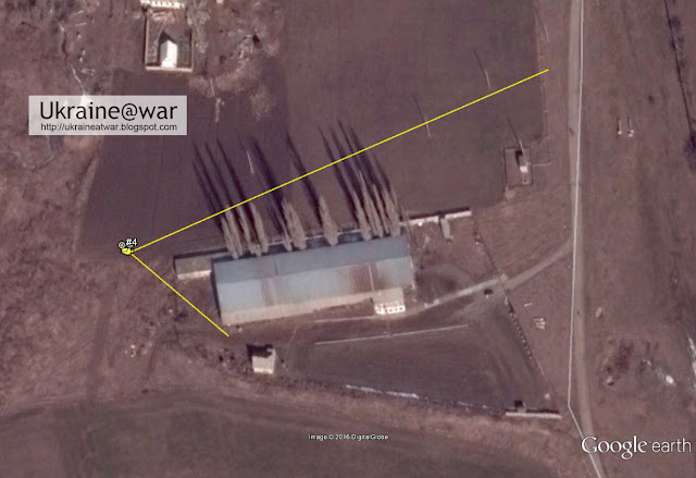
They are in the outskirts of Dyakove. When he looks in this direction:

we can see smoke rising. He exactly looks towards their former positions were things are burning now:

This video shows the destruction that the Russian artillery created at their former camp.
video #5
Driving through Dyakove:
They are driving like this:

video #6
Driving over the plains:
Very hard to geolocate video. But it has to be in between some of the others. Furthermore the car is switching lanes, zo there must be some kind of 'double road'. Other clues are that there are incidental small bushes at both sides and there is smoke somewhere in the distance.
The best shot for this location/screenshot:

is somewhere on this road:

The double road is there. The road bends slightly to the right. There are small bushes at both sides. And... surprisingly there is a clear burnmark from some bushfire in the distance.
Most likely it is somewhere here.
video #7
They are pausing for a moment and in the distance something is burning:
This screenshot:

is taken like this:

The Google Earth image has more tracks that were created by groups that passed later on.
Next thing we can do is see what the origin of the smoke is (red box):

We see a group of trees and a single tree. We can locate these (and other trees) on the map:

and match them with the screenshot:

We draw the red line in Google Earth towards the red box. Then we look down the line to see what is there:

There are known wrecks in the vicinity, but not exactly on the red line which (if we did the previous step right) is a must. But there are impact craters on the line though:

So it looks like artillery is coming down in the area, but no vehicles were hit yet.
video #8abc
Next three videos shot from the same location.
Ukrainian units can be seen crossing a field. Smoke from impacts and/or hits (purple box) can be seen behind the tree line (green box). A smaller line of trees is in the distance (yellow box).
This screenshot:

is taken like this:

Vehicle icons = known wrecks
Purple line = direction of smoke
Red lines = visible tracks in Google Earth
yellow lines = view from camera
The soldier in the video talks about that they lost an Uaz and a Zil. The first being some sort of jeep and the second a truck.
Indeed both a Uaz and Zil can be seen in the Krasnyi Luch destruction video as this screenshot shows:

as well as their location in Google Earth along the route that they had been driving:

video #9
They drive along a treeline, with also a treeline in front of them and behind them. Furthermore it is in the evening and the sun is setting in front of them. So they are driving westwards. There are not many locations that have (at least) three treelines like that.


The blueish-purple areas indicate where impacts can be seen. The orange square has two, one of which must have been the fire we can see in the middle of the field in the video. In the distance we can see many fires, which corresponds with the multiple impacts seen in the red square.

They are lucky that this dense volley missed them by 1 km...
Video #10
Screenshots:


Looking back there is a sunrise (it must be like 4 'o clock in the morning and they must have spend the night somewhere). On the left side, there are impacts from shelling (again). There are electricity lines next to the road. And when they pass the treeline in front of them, the path to the left has trees on both sides.
They drove like this:

blue-purple areas = impact crater some of which were made when the video was recording
Video #11a/b
This screenshot from the first video:

is taken like this:

Yellow vehicle icons = wrecks visible on Google Earth, likely from later groups
A large group of vehicles has assembled here. They made it to the other side. Although at this point they are still not completely safe yet.
The entire escape route now looks like this:

red lines = visible unique tracks in Google Earth
orange lines = roads and paths also visible in older satellite images
green line = Krasny Luch operation frontline 6/12-8
Another escape video #12
This video tells one soldiers story of his retreat from Dolzhansky border crossing:
At the end there are three shots with convoys on the route back. The first two were filmed at approximately the same location as video #7, since the trees in the distance match:

But the vehicles don't match. So it seems to have been another group taking the same/similar route out.
That third shot was taken like this within Dyakove:

What's interesting is this truck with trailer:

The pattern on the trailer exactly matches this one from the Krasny Luch wrecks video (which shows a lot/most of the wrecks in the area).

It means it didn't make it to the other side! And it looks like it got stuck while trying to cross a ditch.
It was at this location (yellow circle; 48° 1'48.37"N 38°59'51.25"E) a little bit before the UAZ and ZIL from the other group:

It means it didn't make it to the other side! And it looks like it got stuck while trying to cross a ditch.
It was at this location (yellow circle; 48° 1'48.37"N 38°59'51.25"E) a little bit before the UAZ and ZIL from the other group:
No comments:
Post a Comment